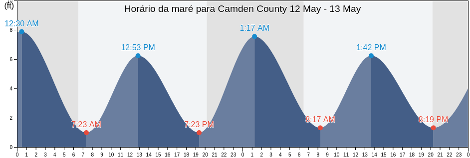
Sexta-feira 19 abril 2024, 10:29 EDT (GMT -0400). No momento, a maré está baixando em Camden County. Como se pode ver no gráfico, a maré mais alta de 6.23ft foi às 06:23 e a maré mais baixa de 0.98ft foi às 00:49 Clique aqui para ver as marés da semana em Camden County.
A próxima maré alta é às
18:52
A próxima maré baixa é às
13:15
Tabela de mares Camden County
| Dia | Tabela de mares Camden County |
|
||||
|---|---|---|---|---|---|---|
| 1ª Maré | 2ª Maré | 3ª Maré | 4ª Maré | |||
| sex. 19 | 00:49 ▼ 0.98 ft | 06:23 ▲ 6.23 ft | 13:15 ▼ 0.98 ft | 18:52 ▲ 6.23 ft |
▲ 06:53 | ▼ 19:57 |
| sáb. 20 | 01:40 ▼ 0.98 ft | 07:09 ▲ 6.23 ft | 13:57 ▼ 0.66 ft | 19:37 ▲ 6.56 ft |
▲ 06:52 | ▼ 19:58 |
| dom. 21 | 02:26 ▼ 0.66 ft | 07:51 ▲ 6.56 ft | 14:36 ▼ 0.66 ft | 20:18 ▲ 6.89 ft |
▲ 06:51 | ▼ 19:58 |
| seg. 22 | 03:09 ▼ 0.66 ft | 08:31 ▲ 6.56 ft | 15:12 ▼ 0.33 ft | 20:57 ▲ 7.22 ft |
▲ 06:50 | ▼ 19:59 |
| ter. 23 | 03:49 ▼ 0.33 ft | 09:10 ▲ 6.56 ft | 15:47 ▼ 0.33 ft | 21:36 ▲ 7.22 ft |
▲ 06:49 | ▼ 20:00 |
| qua. 24 | 04:27 ▼ 0.33 ft | 09:49 ▲ 6.56 ft | 16:21 ▼ 0.33 ft | 22:13 ▲ 7.55 ft |
▲ 06:48 | ▼ 20:00 |
| qui. 25 | 05:05 ▼ 0.33 ft | 10:27 ▲ 6.23 ft | 16:55 ▼ 0.33 ft | 22:50 ▲ 7.55 ft |
▲ 06:47 | ▼ 20:01 |
Melhores horários de pesca para Camden County hoje Dia médio de pesca
Maior horário de pesca
De 02:54 às 04:54
Trânsito lunar oposto (Descida da lua)
De 15:21 às 17:21
Trânsito lunar (Subida da lua)
Menor horário de pesca
De 04:18 às 05:18
Por da lua
De 15:51 às 16:51
Nascer da lua
Clique aqui para ver as tábua de maré para pesca da semana em Camden County.
Clima atual em Camden County
Clima
Cobertura de nuvens 14%
Temperatura
72°F
Mínima 67°F/Máxima 80°F
Vento
4 mph
Rajada de vento 6 mph
Umidade
66%
Ponto de condensação da água 60°F
Klicken Sie hier, um das Wetter in Camden County für die Woche zu sehen
Clima de hoje em Camden County
O sol nasceu às 06:53 e o pôr do sol será às 19:57. Haverá 13 horas e 04 minutos de sol e a temperatura média é 74°F. No momento, a temperatura da água é 66°F. e a temperatura média da água é 66°F.
Klicken Sie hier, um das Wetter in Camden County für die Woche zu sehen
