Tabua de mare em Chatham County, Georgia, United States

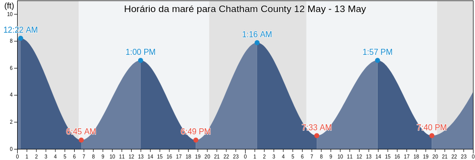
Sexta-feira 19 abril 2024, 17:18 EDT (GMT -0400). No momento, a maré está baixando em Chatham County. Como se pode ver no gráfico, a maré mais alta de 7.22ft é as 19:00 e a maré mais baixa de 0.98ft foi às 00:18 Clique aqui para ver as marés da semana em Chatham County.

Próxima maré alta`

A próxima maré alta é às
19:00

Próxima maré baixa

A próxima maré baixa é às
01:06

Tabela de mares Chatham County

Tábua de maré em Chatham County esta semana
Dia Tabela de mares Chatham County Nascer e pôr do sol
1ª Maré 2ª Maré 3ª Maré 4ª Maré
sex. 1900:18
0.98 ft
06:23
6.89 ft
12:43
0.98 ft
19:00
7.22 ft
06:50 19:57
sáb. 2001:06
0.66 ft
07:11
7.22 ft
13:22
0.66 ft
19:44
7.55 ft
06:49 19:57
dom. 2101:50
0.66 ft
07:54
7.22 ft
13:59
0.66 ft
20:23
7.87 ft
06:48 19:58
seg. 2202:32
0.33 ft
08:34
7.22 ft
14:35
0.33 ft
20:59
8.2 ft
06:47 19:59
ter. 2303:12
0.33 ft
09:11
7.22 ft
15:11
0.33 ft
21:32
8.2 ft
06:46 19:59
qua. 2403:51
0.33 ft
09:46
7.22 ft
15:47
0.33 ft
22:05
8.2 ft
06:45 20:00
qui. 2504:29
0.33 ft
10:20
7.22 ft
16:23
0.33 ft
22:37
8.2 ft
06:44 20:01

Melhores horários de pesca para Chatham County hoje Dia médio de pesca

Maior horário de pesca

De 02:51 às 04:51

Trânsito lunar oposto (Descida da lua)

De 15:18 às 17:18

Trânsito lunar (Subida da lua)

Menor horário de pesca

De 04:17 às 05:17

Por da lua

De 15:48 às 16:48

Nascer da lua

Clique aqui para ver as tábua de maré para pesca da semana em Chatham County.

Clima atual em Chatham County

Parcialmente encoberto

Clima

Cobertura de nuvens 25%
Temperatura

Temperatura

74°F
Mínima 68°F/Máxima 76°F
Vento

Vento

12 mph
Rajada de vento 14 mph
Umidade

Umidade

70%
Ponto de condensação da água 64°F

Klicken Sie hier, um das Wetter in Chatham County für die Woche zu sehen

Clima de hoje em Chatham County

O sol nasceu às 06:50 e o pôr do sol será às 19:57. Haverá 13 horas e 07 minutos de sol e a temperatura média é 73°F. No momento, a temperatura da água é 66°F. e a temperatura média da água é 66°F.

Clima para Chatham County hoje
0 h 3 h 6 h 9 h 12 h 15 h 18 h 21 h 24 h
Parcialmente encobertoParcialmente encobertoParcialmente encobertoParcialmente encobertoParcialmente encobertoParcialmente encobertoParcialmente encobertoParcialmente encobertoParcialmente encoberto
71°F74°F72°F74°F76°F74°F72°F72°F71°F

Klicken Sie hier, um das Wetter in Chatham County für die Woche zu sehen

Mais informações sobre a maré em Chatham County

Regiões e cidades em Chatham County, Georgia, United States
2nd Street (Tybee Island)Fort Mcallister (Ogeechee River)Raccoon Key
610 Statute Mile MarkFort McAllister Ogeechee RiverRange A Light Bear River
Beach HammockFort PulaskiRomerly Marsh Creek
Bear River EntranceFort Pulaski 1.8 miles aboveS C L Rr Bridge
Bloody Point (Daufuskie Island)Fort Pulaski 4.8 miles aboveS.C.L. Rr. Bridge
Bloody Point Daufuskie IslandGood Hope Landing (South Of)Savannah
Bloody Pt. 0.5 mile north of New RiverGood Hope Landing South OfSavannah Bull Street
Bloody Pt. 0.5 mile west of New RiverGreys IslandSavannah River Entrance (between jetties)
Bradley Point (Bradley River)Hargray Pier (Daufuskie Island)Savannah River Entrance Fort Pulaski
Bradley Point Bradley RiverHargray Pier Daufuskie IslandSavannah Sheraton Resort Hotel
Bradley Point NNE ofHighway Bridge (Ogeechee River)Savannah southeast of highway bridge
Bull River 2 miles below hwy. bridgeHighway Bridge Ogeechee RiverSeaboard Coast Line Railroad
Burnside Island SE of Burnside RiverIsle of HopeSkidaway Island
Burntpot Island west of Skidaway RiverIsle of Hope (Skidaway River)Skidaway Island N End Wilmington River
Butter Bean BeachIsle of Hope City SE of Skidaway RiverSkidaway Narrows
Cane Patch Creek EntranceIsle of Hope City Skidaway RiverSkidaway River north entrance
Coffee Bluff (Forest River)Isle Of Hope Skidaway RiverSouth Channel western end
Coffee Bluff Forest RiverJoe's CutSouth of Kilkenny Creek Entrance
Cook Landing CemeteryJoes Cut Wilmington RiverSouth Ossabaw Island Bear River
Daufuskie Landing (Daufuskie Island)Kilkenny Club (Kilkenny Creek)St. Catherines Sound Entrance
Daufuskie Landing Daufuskie IslandKilkenny Club Kilkenny CreekThunderbolt
Daufuskie Landing Light south ofKing Island west ofThunderbolt SE of Wilmington River
Delegal Creek MarinaKings Island Channel Savannah RiverTurnbridge Landing (Salt Water Creek)
Doughboy IslandLazaretto Creek Entrance N of Bull RiverTurnbridge Landing Salt Water Creek
Dutch Island SE of Skidaway RiverLittle Back River Hwy. 17 Back River S.C.Tybee Creek Entrance
Egg IslandsLittle Don Island east of Vernon RiverTybee Island
Elba Island Cut NE of Savannah RiverLittle Ogeechee River EntranceTybee Light
Elba Island NE of Savannah RiverLittle Ogeechee River Entrance north ofTybee South End Sand Bar
Elba Island west of Savannah RiverLittle Wassaw Island SW ofVernon R. 1.2 miles S of Possum Point
Entrance off Beach HammockLong Island NNE of Skidaway RiverVernon View
Entrance off Wassaw IslandLong Island south of Skidaway RiverVernon View (Burnside River)
Fields Cut (Wright River)McQueen Island CutWalls Cut Turtle Island
Fields Cut Wright RiverMontgomeryWassaw Island N of E end Wassaw Sound
Fig Island north of Back RiverMontgomery Vernon RiverWassaw Island SSW of
Florida Passage (Bear River)North EntranceWhitemarsh Island
Florida Passage (Ogeechee River)North of Big Tom Creek EntranceWilmington Island
Florida Passage (south)Northwest of Newell Creek EntranceWilmington Island SSE of Bull River
Florida Passage Bear RiverOatland Island north tipWilmington R. 0.5 mi. S of Turners Creek
Florida Passage N of Ogeechee RiverOdingsell River EntranceWilmington R. ent. south channel
Florida Passage Ogeechee RiverPelican PointWilmington River ent. off Cabbage Island
Fort JacksonPigeon Island SSE of Skidaway RiverWright R. 0.2 mile above Walls Cut
Fort Mc Allister Ogeechee RiverPort Wentworth 0.2 mile above