PT
°F
Mudar as medidas
Metros
Pés
°C
°F
km/h
mph
nós
am/pm
24-horas
Suas configurações foram atualizadas
Alterar o idioma
Deutsch
Español
Italiano
Nederlands
中文
English
Français
日本語
Português
Hoje
7 dias
Clima
Pesca
O mar
Marés de
United States
Marés de
New York
Marés de
New York County
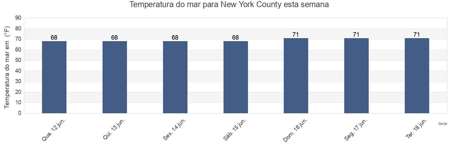
Temperatura da água em New York County
Temperatura do mar em New York County esta semana
Mais informações sobre a maré em New York County
Marés de hoje
Marés esta semana
Clima
Tábua de maré para pesca
Regiões e cidades em New York County, New York, United States
120th Street
Gueque
Mill Rock northeast of
130th Street
Hallets Cove
Mill Rock west of
37th Avenue, Long Island City, East River
Harlem River (Randalls Island)
New York City (East 41st Street)
48th Street
Harlem River Randalls Island
Off Winthrop Ave. Astoria
56th St
Hell Gate (East River)
Pier 67 off 19th Street
7th Avenue
Hell Gate Wards Island
Port Morris
Mostrar mais locais
81st Street
Hell Gate(off Mill Rock)
Port Morris (Stony Point)
Bananas Point
Horns Hook
Queensboro Bridge
Cromakill Creek N J Turnpike
Hunters Point (Newtown Creek)
Roosevelt Island, north end, East River
East 107th Street
Hunters Point Newtown Creek
South Brother Island NW of
East 110th Street
Lawrence Point
Turtles
East 19th Street
Liberty Island
Union Stock Yards
East 27th Street, Bellevue Hospital, East River
Macombs Dam Bridge
Wards Island
East 41st Street New York City
Madison Ave. Bridge
west of off 63rd Street
east of
Madison Avenue Bridge, Harlem River
west of off 67th Street
east of off 36th Avenue
Manhattan
west of off 75th Street
Edgewater
Manhattan 26th street
Willis Ave. Bridge 0.1 mile NW of
Grants Tomb
Manhattan off 31st Street
Wolcott Avenue
Marés perto de New York County
Turtles
7th Avenue
Manhattan
56th St
east of off 36th Avenue
west of off 67th Street
west of off 75th Street
west of off 63rd Street
Queensboro Bridge
east of