PT
°F
Mudar as medidas
Metros
Pés
°C
°F
km/h
mph
nós
am/pm
24-horas
Suas configurações foram atualizadas
Alterar o idioma
Deutsch
Español
Italiano
Nederlands
中文
English
Français
日本語
Português
Hoje
7 dias
Clima
Pesca
O mar
Marés de
United States
Marés de
Rhode Island
Marés de
Washington County
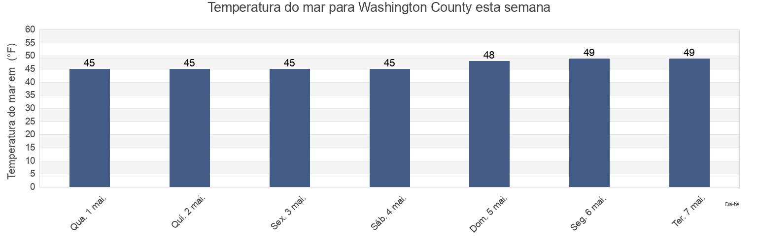
Temperatura da água em Washington County
Temperatura do mar em Washington County esta semana
Mais informações sobre a maré em Washington County
Marés de hoje
Marés esta semana
Clima
Tábua de maré para pesca
Regiões e cidades em Washington County, Rhode Island, United States
2.4 miles southwest of
Lake Montauk
Point Judith Harbor Of Refuge
4 miles north of
Lewis Point 6.0 miles WNW of
Pond entrance - Point Judith
Allen Harbor
Lewis Pt. 1.0 mile southwest of
Quonochontaug Beach
Ashaway
Lewis Pt. 1.5 miles west of
Quonochontaug Beach 1.1 miles S of
Atlantic Terrace
Lighthouse (Point Judith)
Quonochontaug Beach 3.8 miles S of
Block Island (Great Salt Pond)
Little Narragansett Bay entrance
Richmond Island
Mostrar mais locais
Block Island (Old Harbor)
Mansion Beach
Roger Wheeler State Beach
Block Island (SW end), Block Island Sound
Matunuck-Deep Hole
Salty Brine State Beach
Block Island (West)
Matunuck-The point
Sandy Point 2.1 miles NNE of
Block Island East (New Shoreham)
Misquamicut State Beach
Sandy Point 4.1 miles northwest of
Bradford
Monahans Dock
Sandy Pt. 1.5 miles north of
Cerberus Shoal 1.5 miles east of
Montauk
Scarborough State Beach
Charlestown
Montauk Harbor Entrance
Shagwong Reef & Cerberus Shoal
Charlestown Breachway Beach
Montauk Point - Turtles
Southwest Ledge
Clay Head 1.2 miles ENE of
Montauk Point 1 mile northeast of
Southwest Ledge 2.0 miles west of
Crescent Beach
Montauk Point 1.2 miles east of
Southwest Point Block Island
East Beach Ninigret Conservation Area
Montauk Point 5.4 miles NNE of
Stonington
East Matunuck State Beach
Moonstone Beach
Wakefield-Peacedale
East Pt. 4.1 miles S of Fishers Island
Napatree Jetty
Watch Hill Point
Exeter
Napatree Point 0.7 mile southwest of
Watch Hill Point 2.2 miles east of
Fortress
Narragansett Beach
Watch Hill Point 5.2 miles SSE of
Galilee Beach Club Beach
Narragansett Pier
Watch Hill Point 5.3 n.mi. SE of
Great Salt Pond ent. 1 mile NW of
Narragansett Town Beach
Weekapaug Point (Block Island Sound)
Great Salt Pond entrance
North Bar
Weekapaug Point Block Island Sound
Green Hill Point 1.1 miles south of
North Kingstown
Westerly
Harbor of Refuge south entrance
North Kingstown Beach
Westerly (Pawcatuck River)
Hopkinton
North Pier (Narragansett)
Westerly Pawcatuck River
K38/39
Old Harbor Pt. 0.5 mile southeast of
Wicopesset island NE of
Kingston
Point Judith (Harbor Of Refuge)
Marés perto de Washington County
Charlestown Breachway Beach
Charlestown
East Beach Ninigret Conservation Area
Green Hill Point 1.1 miles south of
Moonstone Beach
Matunuck-Deep Hole
East Matunuck State Beach
Pond entrance - Point Judith
Matunuck-The point
Salty Brine State Beach