Tabua de mare em Beaufort County, South Carolina, United States

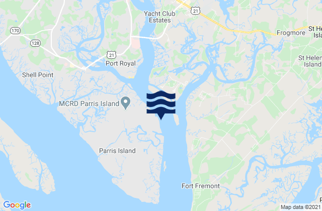
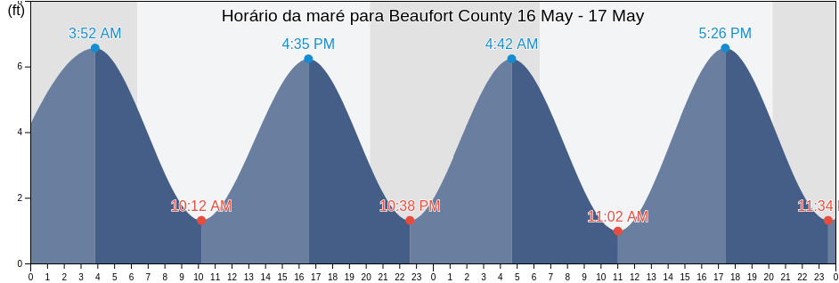
Sexta-feira 26 abril 2024, 10:19 EDT (GMT -0400). No momento, a maré está subindo em Beaufort County. Como se pode ver no gráfico, a maré mais alta de 7.55ft é as 23:10 e a maré mais baixa de 0.33ft foi às 05:02 Clique aqui para ver as marés da semana em Beaufort County.

Próxima maré alta`

A próxima maré alta é às
10:53

Próxima maré baixa

A próxima maré baixa é às
16:55

Tabela de mares Beaufort County

Tábua de maré em Beaufort County esta semana
Dia Tabela de mares Beaufort County Nascer e pôr do sol
1ª Maré 2ª Maré 3ª Maré 4ª Maré
sex. 2605:02
0.33 ft
10:53
6.56 ft
16:55
0.33 ft
23:10
7.55 ft
06:40 20:01
sáb. 2705:42
0.33 ft
11:33
6.23 ft
17:35
0.33 ft
23:53
7.55 ft
06:39 20:01
dom. 2806:26
0.66 ft
12:21
6.23 ft
18:19
0.66 ft
06:38 20:02
seg. 2900:45
7.22 ft
07:14
0.66 ft
13:17
6.23 ft
19:11
0.66 ft
06:37 20:03
ter. 3001:45
7.22 ft
08:10
0.98 ft
14:19
6.23 ft
20:12
0.98 ft
06:36 20:03
qua. 102:49
7.22 ft
09:13
0.66 ft
15:22
6.56 ft
21:24
0.98 ft
06:35 20:04
qui. 203:53
7.22 ft
10:17
0.66 ft
16:25
6.89 ft
22:37
0.66 ft
06:34 20:05

Melhores horários de pesca para Beaufort County hoje Dia médio de pesca

Maior horário de pesca

De 09:30 às 11:30

Trânsito lunar oposto (Descida da lua)

De 22:01 às 00:01

Trânsito lunar (Subida da lua)

Menor horário de pesca

De 07:34 às 08:34

Por da lua

De 22:31 às 23:31

Nascer da lua

Clique aqui para ver as tábua de maré para pesca da semana em Beaufort County.

Clima atual em Beaufort County

Pancadas de chuva próximo

Clima

Pancadas de chuva próximas
Cobertura de nuvens 75%
Temperatura

Temperatura

70°F
Mínima 65°F/Máxima 70°F
Vento

Vento

14 mph
Rajada de vento 20 mph
Umidade

Umidade

72%
Ponto de condensação da água 61°F

Klicken Sie hier, um das Wetter in Beaufort County für die Woche zu sehen

Clima de hoje em Beaufort County

O sol nasceu às 06:40 e o pôr do sol será às 20:01. Haverá 13 horas e 21 minutos de sol e a temperatura média é 67°F. No momento, a temperatura da água é 64°F. e a temperatura média da água é 64°F.

Clima para Beaufort County hoje
0 h 3 h 6 h 9 h 12 h 15 h 18 h 21 h 24 h
Parcialmente encobertoParcialmente encobertoPancadas de chuva próximoPancadas de chuva próximoParcialmente encobertoPancadas de chuva próximoParcialmente encobertoParcialmente encobertoParcialmente encoberto
67°F70°F65°F70°F68°F67°F65°F67°F68°F

Klicken Sie hier, um das Wetter in Beaufort County für die Woche zu sehen

Mais informações sobre a maré em Beaufort County

Regiões e cidades em Beaufort County, South Carolina, United States

Albergottie CreekCoosaw Island South of Morgan RiverNew River (Rt. 170 Bridge)
Albergottie Creek Rt. 21 BridgeCorning Landing Whale BranchOtter Island
Ashe Island Cut St. Helena SoundCowen Creek (Route 21 Bridge)Parris Island (Marine Corps Recruit Depot)
Ashe Island Cut SW of Coosaw RiverCowen Creek Rt. 21 BridgeParris Island Beaufort River
Ashepoo Coosaw CutoffDaufuskie IslandParris Island Lookout Tower Broad River
Ashepoo Coosaw Cutoff ICWWDaws Island SE of Broad RiverParris Island Marine Corps Recruit Depot
Ashepoo River off Jefford Creek entranceDaws Island south of Chechessee RiverParrot Creek Coosaw Island
Bailey's LandingDistant Island (Cowen Creek)Pelican Bank St. Helena Sound
Baileys Landing (Okatee River Colleton River)Distant Island Cowen CreekPeters Point (St. Pierre Creek)
Battery Creek (4 Mi. Above Entrance)Distant Island Creek (Upper End Cowen Creek)Pinckney Island (Mackay Creek Chechessee River)
Battery Creek 4 Mi. Above EntranceDistant Island Creek Upper End Cowen CreekPinckney Island Mackay Creek Chechessee River
Bay Point Island S of Broad River entranceDolphin HeadPine Island (Ramshorn Creek Cooper River)
BeaufortEdding Point (Edding Creek)Pine Island Ramshorn Creek Cooper River
Beaufort Airport Beaufort RiverEdding Point Edding CreekPine Island South Edisto River
Beaufort Beaufort RiverEdisto Beach (Edisto Island)Port Royal
Beaufort RiverEdisto Beach Edisto IslandPort Royal Plantation (Hilton Head Island)
Beaufort River EntranceEdisto Marina (Big Bay Creek Entrance)Port Royal Plantation Hilton Head Island
BlufftonEdisto Marina Big Bay Creek EntrancePort Royal Plantation Tower east of
Braddock Point (Hilton Head Island)Egg Bank St. Helena SoundPort Royal Sound
Braddock Point Hilton Head IslandEuhaw Creek (2.5 Mi. Above Entrance)Ramshorn Creek Light E of Cooper River
Braddock Point SW of Calibogue SoundEuhaw Creek 2.5 Mi. Above EntranceRose Dew Creek
Brickyard Point (Brickyard Creek)Fenwick Island Cut South Edisto RiverRt 170 bridge
Brickyard Point Brickyard CreekFort FremontSams Point (Lucy Point Creek)
Broad Creek (Hilton Head Island)Fripp InletSams Point Lucy Point Creek
Broad River Bridge S of Broad RiverFripp Inlet BridgeSams Point Northwest of Coosaw River
Broad River Entrance Point Royal SoundFripp Inlet Fripp IslandSavage Creek (Bull Creek)
Bull Creek (Bull Island South Cooper River)Fripp IslandSavage I. Savage Creek Bull Creek
Bull Creek Bull Island South Cooper RiverHaig Point (Daufuskie Island Cooper River)Scott Creek 0 5 mi above ent Big Bay Creek
Bull Island NorthHaig Point Daufuskie Island Cooper RiverShell Point
BurtonHaig Point Light NW of Cooper RiverShell Point (Hwy. 170 Bridge)
Byrd Creek Entrance SE of Broad RiverHarbor River BridgeSkull Creek (North Entrance Hilton Head Island)
Calibogue Cay (Broad Creek Hilton Head Island)Hilton HeadSkull Creek (South Entrance Hilton Head Island)
Calibogue Cay Broad Creek Hilton Head IslandHilton Head IslandSkull Creek north entrance
Calibogue SoundHunting IslandSkull Creek North Entrance Hilton Head Island
Callawassie Creek (Colleton River)Hutchinson IslandSkull Creek south entrance
Callawassie Island (South Colleton River)Hutchinson Island Ashepoo RiverSkull Creek South Entrance Hilton Head Island
Callawassie Island Bridge (Colleton River)Hwy 170 bridgeSouth Edisto River entrance
Callawassie Island Bridge Colleton RiverJenkins Creek (1 Mi. Above Entrance)Southeast Channel entrance
Callawassie Island South Colleton RiverJenkins Creek (Polawana Island)Spanish Wells Calibogue Sound
Capers Creek (Cowen Creek St. Helena Island)Jenkins Creek 1 Mi. Above EntranceStation Creek (County Landing)
Capers Creek Cowen Creek St Helena IslandJenkins Creek Polawana IslandStation Creek (West End)
Capers Island (Trenchards Inlet)Johnson Creek Bridge (Hunting Island)Station Creek County Landing
Capers Island Trenchards InletLaurel BayStation Creek West End
Carters Dock (Big Bay Creek)Lemon IslandSummerhouse Point (Bull River)
Carters Dock Big Bay CreekLemon Island South Chechessee RiverSummerhouse Point Bull River
Chechessee Bluff (Chechessee River)Little Barnwell I. E of Whale Branch RiverThe Folly Hilton Head Island
Chechessee Bluff Chechessee RiverLucy Point Creek EntranceTriton Head
Chowan CreekMacKay Creek south entranceVictoria Bluff
Clarendon PlantationMarine Corps Air Station (Brickyard Creek)Village Creek Cemetery
Club Bridge Creek Ent. (Trenchards Inlet)Marine Corps Air Station Brickyard CreekVillage Creek Entrance
Coffin PointMoreland CemeteryWhale Branch Entrance
Colleton River EntranceMorgan Island NE of Coosaw RiverWhale Branch River
Combahee RiverMorgan Island North end Coosaw River