PT
°F
Mudar as medidas
Metros
Pés
°C
°F
km/h
mph
nós
am/pm
24-horas
Suas configurações foram atualizadas
Alterar o idioma
Deutsch
Español
Italiano
Nederlands
中文
English
Français
日本語
Português
Hoje
7 dias
Clima
Pesca
O mar
Marés de
United States
Marés de
Virginia
Marés de
City of Hampton
Temperatura da água em City of Hampton
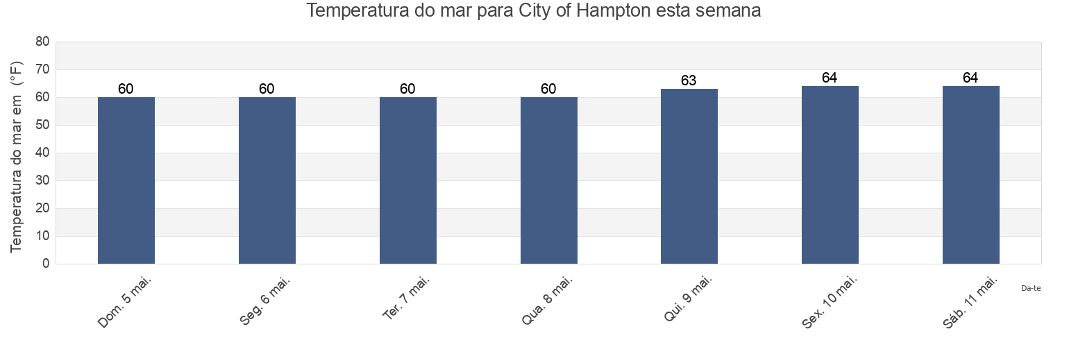
Temperatura do mar em City of Hampton esta semana
Mais informações sobre a maré em City of Hampton
Marés de hoje
Marés esta semana
Clima
Tábua de maré para pesca
Regiões e cidades em City of Hampton, Virginia, United States
0.15nm WSW of Pier No.2
Hampton
Norfolk Harbor Reach (Buoy R 8)
0.2 mile south of
Hampton River
Old Point Comfort
0.55 n.mi. east of
Hampton River entrance
Pig Point
0.8 mile SW of shipbuilding plant
Hampton Roads
Pig Point 1.8 miles northeast of
0.9 mile southwest of
Hampton Roads (sewells Point)
Sewells Point
1.5 miles SW of shipbuilding plant
Hampton Roads entrance midchannel
Sewells Point (Naval Station Norfolk)
Mostrar mais locais
Buckroe Beach
James River Entrance
Sewells Point pierhead
Cape Henry Light 8.3 mi. NW of
Middle Ground 1 mile south of
Thimble Shoal Channel (west end)
Channel middle
Newport News
Thimble Shoal Channel 2.4 n.mi east of Ft. Monroe
Dandy Haven Marina
Newport News Channel west end
Willoughby Bay entrance
East Hampton
Norfolk Harbor Reach (Buoy R '8')
Willoughby Spit 0.8 mile northwest of
Marés perto de City of Hampton
East Hampton
Buckroe Beach
Hampton River entrance
Hampton
Dandy Haven Marina
Messick Point Back River
Hampton River
Messick Point (Back River)
Poquoson
Old Point Comfort