PT
°F
Mudar as medidas
Metros
Pés
°C
°F
km/h
mph
nós
am/pm
24-horas
Suas configurações foram atualizadas
Alterar o idioma
Deutsch
Español
Italiano
Nederlands
中文
English
Français
日本語
Português
Hoje
7 dias
Clima
Pesca
O mar
Marés de
United States
Marés de
Virginia
Marés de
Northampton County
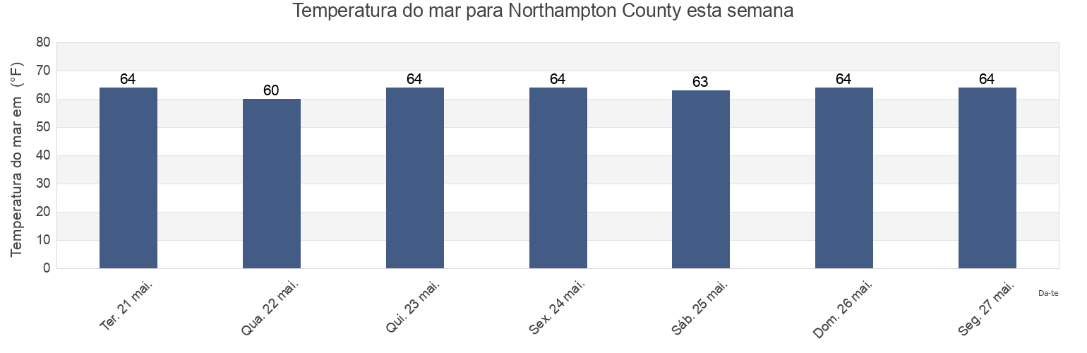
Temperatura da água em Northampton County
Temperatura do mar em Northampton County esta semana
Mais informações sobre a maré em Northampton County
Marés de hoje
Marés esta semana
Clima
Tábua de maré para pesca
Regiões e cidades em Northampton County, Virginia, United States
Butler Bluff 2.1 n.mi. WSW of
Fishermans I. 0.4 mile west of
Kiptopeke Beach
Cape Charles
Fishermans I. 1.1 miles northwest of
Old Plantation Flats Lt. 0.5 mi. W of
Cape Charles City 3.3 n.mi. west of
Fishermans I. 1.4 n.mi. WNW of
Old Plantation Light
Cape Charles Coast Guard Station
Fishermans Island
Oyster Harbor
Cape Charles Harbor
Fishermans Island 0.5 n.mi. SW of
Sand Shoal Inlet (coast Guard Station)
Cape Charles off Wise Point
Fishermans Island 1.4 miles WSW of
Ship Shoal Inlet
Mostrar mais locais
Cherrystone Inlet
Fishermans Island 1.7 n.mi. south of
Smith Beach
Chesapeake Channel (bridge tunnel)
Fishermans Island 2.45nm south of
Smith Island (coast Guard Station)
Chesapeake Channel (Buoy '15')
Fishermans Island 3.2 miles WSW of
Smith Island Shoal southeast of
Chesapeake Channel (Buoy 15)
Great Machipongo Inlet (inside)
Wolf Trap Light 5.8 miles east of
Church Neck Point 1.9 n.mi. W of
Hog Island
Wolf Trap Light 6.1 n.mi. ENE of
Eastville
Hungars Beach
York River Entrance Channel (SE end)
Exmore
Kiptopeke
York Spit Channel N of Buoy 26
Marés perto de Northampton County
Oyster Harbor
Eastville
Cherrystone Inlet
Cape Charles
Cape Charles Coast Guard Station
Cape Charles Harbor
Smith Beach
Hungars Beach
Sand Shoal Inlet (coast Guard Station)
Old Plantation Light